Karte/Reinshagen: Unterschied zwischen den Versionen
Inhalt gelöscht Inhalt hinzugefügt
K Änderungen von Ralph Oesker (Diskussion) wurden auf die letzte Version von Mdbw zurückgesetzt |
Keine Bearbeitungszusammenfassung |
||
| Zeile 1: | Zeile 1: | ||
<OniFrame src=" |
<OniFrame src="https://maps.google.com/maps/ms?msa=0&msid=207415893199080100250.00000111c7feebd42df42&ie=UTF8&ll=53.774876,12.35161&spn=0.03321,0.073804&t=m&output=embed" height="425" width="350" style="padding:0px; margin:0px;" |
||
scrolling="no" marginheight="0" marginwidth="0" frameborder="0"></OniFrame> |
scrolling="no" marginheight="0" marginwidth="0" frameborder="0"></OniFrame> |
||
Version vom 22. August 2013, 19:49 Uhr
<OniFrame src="https://maps.google.com/maps/ms?msa=0&msid=207415893199080100250.00000111c7feebd42df42&ie=UTF8&ll=53.774876,12.35161&spn=0.03321,0.073804&t=m&output=embed" height="425" width="350" style="padding:0px; margin:0px;"
scrolling="no" marginheight="0" marginwidth="0" frameborder="0"></OniFrame>
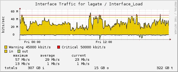
Live Traffic
http://www.opennet-initiative.de/graphen/lagate-inout.png
- Siehe auch Projekt Reinshagen